I had a deposition today in Pasadena. Google Maps, Yahoo! Maps, and Mapquest will all tell you that the way I should have gone was Highway 14 south to Interstate 5 south, and then to merge to eastbound Interstate 210. In the mornings, that commute would be about two hours.
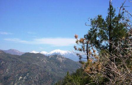 So instead, I stayed off the freeways almost entirely and took the Angeles Forest Highway. It goes through several segments — Kentucky Valley, Aliso Canyon, Mill Creek and Monte Cristo, Big Tujunga Canyon, and Clear Creek. Then it merges into Angeles Crest Highway, going down the side of the San Gabriel Mountains into La Cañada-Flintridge. From the time I left Palmdale to the time of my arrival at my destination in Pasadena was one hour and one minute. To the right is a picture of the kind of scenery one encounters up in the San Gabriels; I believe this picture is actually of Devil’s Canyon next to the Crest Highway somewhat to the east of of the Forest Highway route, but you can get a taste of the flavor from this picture.
It helps to know the area. Here, I’m a native. Here, I know the tricks — I know the mountain route is twisty and not as safe as a regular freeway, so I respect the mountain. But I also know that if you give the mountain respect, it will give you rewards. In this case, it gave me an hour of my time each way, and it freed me from the frustration of what is becoming Southern California’s most greuling commute.